SAILING WEATHER SCHOOL (PART1) - WHAT YOU REALLY NEED TO KNOW ABOUT WEATHER!
*2 places remaining*
The next Sailing Weather School (Part 1) will be held on Saturday 7th February 2008 and I am accepting bookings now.
Whether you are a new to sailing, or an experienced yachty, you will find Weather School fascinating. My aim is get you into the mind of a forecaster and show you why the weather works, building your confidence in making your own predictions and helping you to make sense of the plethora of weather information available on the internet. The cost of the full day course is £115 (inc VAT) and this includes lunch and refreshments throughout the course. For more information or to book online see http://www.weatherschool.co.uk
************************************************************************
Hello again,
As 2008 draws to a close I thought some of you might be planning to escape the office and enjoy yourselves over the next few days, and so here is a forecast to take you through the New Year.
Remember that Weatherweb.TV is updated every day with the very latest forecasts, and you can learn more about the weather at our learning channel. You can also speak to us via WeatherLive (0906 5151 0046 at £1.50 p.min, 01902 895252 at £12 per call) or you can book forecasts by email.
Whatever your plans, have a great night tomorrow and I wish you, your family and friends a peaceful 2009.
If you know anyone who’d like to receive this email each week just tell them to send a request to join to sailingweather-subscribe@weatherweb.net
Best wishes,
Simon
WEEKEND WEATHER FORECAST
Issued: 1300 Tuesday 30th December 2008
NEW YEAR’S EVE:
High pressure continues to dominate the weather through the day on Wednesday. The high becomes centred over northern England with a NE flow over England and Wales, but more of an easterly through Ireland.
Fog patches may be dense and freezing over the north of England and Scotland, some lingering throughout the day. Elsewhere there will be variable cloud and some fog patches too. Those fog patches lasting throughout the day in some places.
North Sea coasts are always going to be prone to come low cloud, and the fog could lift to low cloud through southern England and Wales too.
Winds will be mainly E-NE 6-10kt (F3) in the south, nearer 12-15kt (F4-F5) in the far southwest. Generally variable 2-4kt (F2) over Scotland and northern England.
NEW YEAR’S DAY:
On Thursday the high has drifted into the North Sea with a southeast flow becoming established everywhere. A cold front may edge into the far southwest of Ireland, but this is going to be a weakening affair with a further cold front affecting the east of Scotland and northeast England.
Once again the forecasting difficulty for Thursday will be deciding where cloud will be, and also where fog may linger.
At the present time it does look like being rather cloudy over much of Scotland, northeast England, the Midlands and East Anglia. The best of any sunshine is likely to be in western Wales, Ireland and western Scotland. Rather hazy, especially in the south.
Winds will be E-SE 2-6kt (F2-F3) but SE 10-12kt (F4) through Ireland and southwest England.
FRIDAY:
High pressure is still in the North Sea through Friday.
Similar weather over the whole country with light winds, variable cloud and the threat of freezing fog patches.
Hazy to the south due to the drift off the continent, and probably a higher chance of the cloud breaking up through southern England.
Winds will be E-SE 8-12kt (F3-F4) but 15kt (F4-F5) in southwest England and southern Ireland.
SATURDAY:
High pressure will be developing across Scotland and remains dominant for all parts of the British Isles.
There is likely to be a fair amount of cloud for most places, the day dry everywhere. Rather hazy conditions with moderate or poor visibility in the south.
The threat of some freezing fog patches across Scotland and parts of northern England which will be slow to clear during the day.
Winds will be mainly ESE-ENE 5-10kt (F3) but variable 2-4kt (F2) over Scotland.
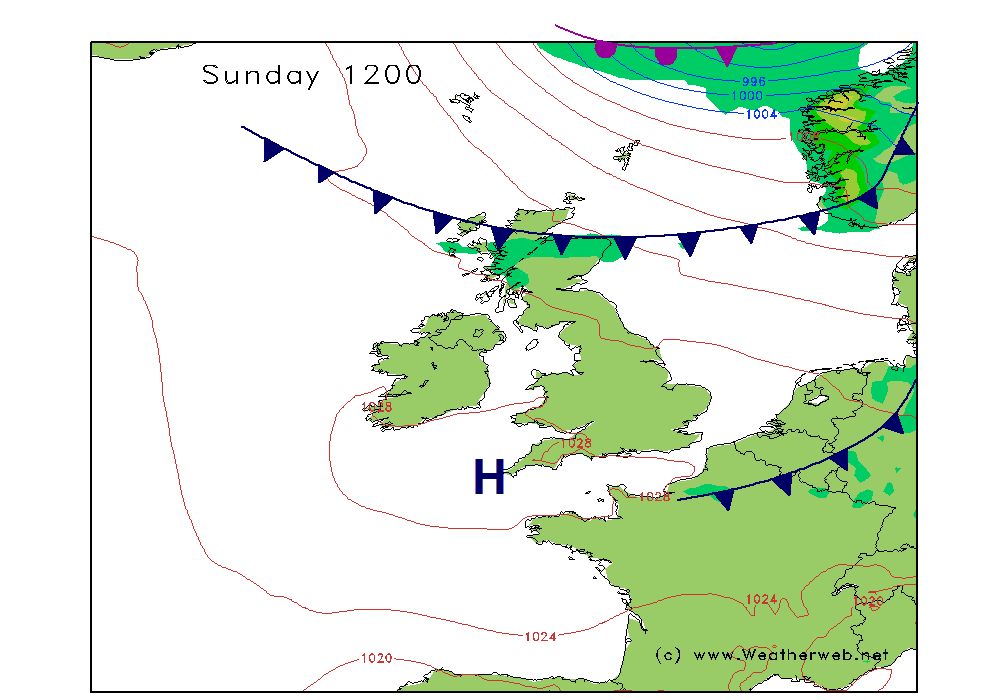
SUNDAY:
Hints that the high pressure sinks south again through Sunday and becomes centred through northern England.
This brings the threat of more widespread, dense, freezing fog across much of the Midlands, northern England and Scotland through Sunday. The fog reluctant to clear many places through the day.
More southern counties of England and northern Scotland, as well as western Ireland should have broken cloud and hazy conditions.
Winds light and variable, generally 1-5kt (F1-F2) but E-SE 5-10kt (F2-F3) over southern Ireland and the far south of England.
**ends**