BOOK & BUY PERSONALISED FORECASTS:
Our forecasters will write a forecast specifically for you, and email it to you.
Simply book in advance and we'll email the forecast to you at the time you specify.
You'll also be able to telephone the forecaster to discuss the forecast.
Forecasts can be made for anywhere in the world, and cost just £17 (inc VAT).
To book your forecast, and to see a sample, go to http://www.weatherweb.net/buy.htm
************************************************************************
Hello again,
With the Bank Holiday Weekend almost upon us I thought you might appreciate an early Weekend Forecast, I have also added a forecast for Monday.
If you have a friend who wants to receive this forecast each week they just need to send an email to sailingweather-subscribe@weatherweb.net
Best wishes,
Simon
WEEKEND WEATHER FORECAST
Issued: 1500 Wednesday 21st May 2008
SATURDAY:
Low pressure is to the south of the country on Saturday, beginning centred over the north of France. A strong east to northeast flow affects much of the British Isles and Ireland, with high pressure to the north.
Most parts of the country will have a fair day. There will be well broken cloud with sunny spells, although it is going to be windy. The best of the sunshine in the west.
The proximity of the fronts to south coast will create more cloud in the far south of England, the threat of some outbreaks of rain for southern Cornwall and Devon. Certainly the north coasts of France and the Channel islands will be cloudy and wet with some heavy periods of rain here.
Winds mainly E-NE 20-30kt (F6-F7) over many areas, nearer E-NE 15-20kt (F5-F6) over Scotland.
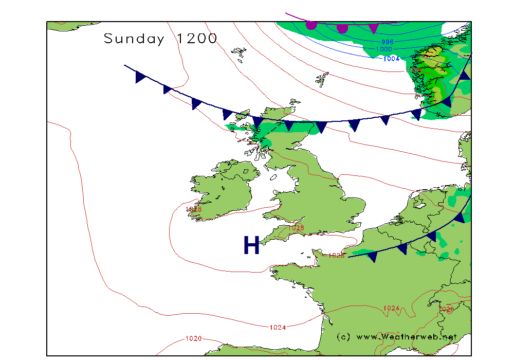
SUNDAY:
Little change on Sunday with low pressure remaining to the south of the country over northern France. The low in the Bay of Biscay becoming complex. High pressure stays to the north of Scotland with a strong E-NE flow through many areas, strongest through England and Wales.
For the far south of England it is likely to be staying cloud through the day. Outbreaks of rain are expected here, with the heaviest of the rain through the Channel Islands and in the far north of France.
The rest of the UK should be generally dry and breezy. There will be some good spells of sunshine, the best of them towards the west.
Winds mainly NE 20-25kt occ 30kt (F6-F7) through the Channel and southern England and Wales, decreasing to E-ENE 15-20kt (F4-F5) across Scotland and Northern Ireland as well as the far north of England.
MONDAY:
(Note this is the chart for 0001 GMT Monday)
Low pressure is still over the north of France on Monday. Cloud and outbreaks of rain extend to the north of the low, associated with the occluded front, mainly affecting southeast England and the eastern Channel. High pressure remains to the north of Scotland.
There is probably a risk of some low cloud drifting onto eastern coasts of England and Scotland at times during Monday, but for most other areas the day should be fair with sunny spells. Western areas always enjoying the best of the sunshine.
Winds NE 20-25kt (F6) for most, occ 30 (F7) in the southeast and Channel. Much light to the north being NE 10 (F3-F4) over northern Scotland.
**ends**