How wide the Grey Dogs?
Posted: Thu May 22, 2014 8:13 pm
What size of boat can get through the Grey Dogs (that little gap just north of Scarba) ?
What depth is there?
What depth is there?
Just to add to that: my charts are on the boat, but I've a VMH sub. and looking at the relevant chart there on maximum zoom it looks similar in size to the paper chart. I measure just over 2mm on screen between the 10m contour lines at the narrowest point and the chart is 1:25,000 so, assuming the screen image is the same as the paper chart, that represents 50m.DaveS wrote:I agree. I've been through a couple of times in my 30 footer and I'd be happy to do so with a much bigger boat.
Yer a braver man than me Dave- the thought of getting it wrong in mah wee boatie doesn't bear thinking about.DaveS wrote:I agree. I've been through a couple of times in my 30 footer and I'd be happy to do so with a much bigger boat.
From the hill on Scarba I've watched kayakers being caught in the Grey Dogs and spat out into the Sound of Luing - looked like fun!
I've not been into loch Etive yet - I'm feart of the 33 kV line E of the bridge. What's your air draft?mm5aho wrote: Can't be much worse than surfing down the Falls of Lora?
DaveS wrote:I've not been into loch Etive yet - I'm feart of the 33 kV line E of the bridge. What's your air draft?mm5aho wrote: Can't be much worse than surfing down the Falls of Lora?
We kayaked in there last weekend, stunningly beautiful it was.DaveS wrote:I've not been into loch Etive yet - I'm feart of the 33 kV line E of the bridge. What's your air draft?mm5aho wrote: Can't be much worse than surfing down the Falls of Lora?
Well, according to the plate in the boat its air draught is 14m, but that's the mast head, and aerials and things probably add another metre, so call it 15m. The chart gives the bridge clearance as 14m and the power line safe clearance as 13m. (IIRC these are measured from MHWS.) I don't have access here to the proper tidal information for Connel, but Easytide shows only a 0.5m difference in high water over the next 7 days. At neaps a HW passage under the bridge might be possible, but if so I think I'd then want to wait until low water before going under the power line, which would increase clearance by 1.5m. I entirely accept the point about keeping well to the north to avoid the sag. However, the underlying worry is that getting it wrong and clipping the bridge might cost me my VHF aerial, whereas getting it wrong with the power line would probably be terminal.Shard wrote:DaveS wrote:I've not been into loch Etive yet - I'm feart of the 33 kV line E of the bridge. What's your air draft?mm5aho wrote: Can't be much worse than surfing down the Falls of Lora?
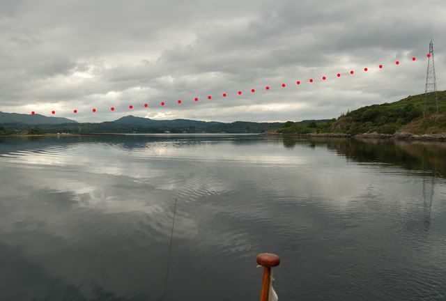
I thought the problem for your mast is the bridge itself. Even your mast would easily clear the leccy lines. I took a photograph and marked in the lines so that you can see clearance by passing close to the north/west side. I'll have a look for the pic - it's on an old thread.
What a useful site! Now the only missing bit of critical information is Connel MHWS, which I'm sure is in the pilot, but that's on board the boat. Anyone know?wully wrote:We kayaked in there last weekend, stunningly beautiful it was.DaveS wrote:I've not been into loch Etive yet - I'm feart of the 33 kV line E of the bridge. What's your air draft?mm5aho wrote: Can't be much worse than surfing down the Falls of Lora?
Found a deserted beach to camp on, had a barbie, fed the midges, ogled the scenery.
Paddled back out down wind and tide.
Nice.
From my yak the cables looked easily do- able and I've seen a fairly big ship in loading at the mine.
Being a big wus I don't fancy The Falls of Lora unless at slack neaps although a year or so ago I watched the mussel farm boat shoot the falls on a big ebb- much respect.
BTW, the first part of the loch is littered with mussel ropes in every little bay but they, and the houses get less and less the farther in you go.( we didn't have time to get all the way to the end, that's for another trip)
http://www.fallsoflora.info has some good foaties and info on the tides.
If it is a recent chart they will be measured from HAT, which is significantly higher than MHWS, so you may have more room than you think.DaveS wrote: Well, according to the plate in the boat its air draught is 14m, but that's the mast head, and aerials and things probably add another metre, so call it 15m. The chart gives the bridge clearance as 14m and the power line safe clearance as 13m. (IIRC these are measured from MHWS.)