Page 1 of 1
Where?
Posted: Sun Apr 29, 2012 7:55 pm
by Silkie
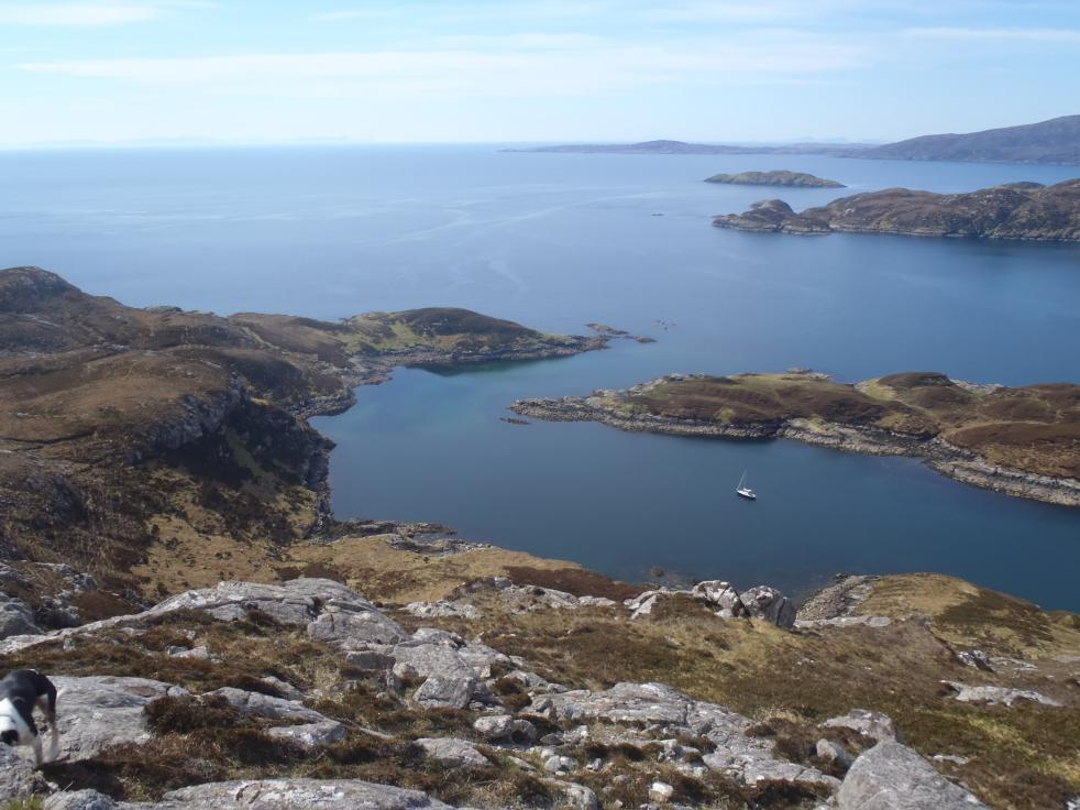
My 3k post!
Re: Where?
Posted: Sun Apr 29, 2012 8:40 pm
by Mark
No idea, but thanks for posting the image. Made my night.
Re: Where?
Posted: Mon Apr 30, 2012 8:48 am
by aquaplane
Do you not get a nose bleed being so high up?
Nice view, thanks.
I'd best have a guess, somewhere in the Ardnamurchan to Cape Wrath book?
EDIT: 'S funny, someone posted a picture of a dog in TOP too

Re: Where?
Posted: Mon Apr 30, 2012 11:13 am
by DaveS
Yes, this photo appeared in TOP, in the "best anchorage" post.
I don't recognise it, but suspect it's on the E side of the Western Isles, either Harris or the Uists. After a bit of squinting at such maps as I have to hand (oh what a nuisance that Shipfinder has been locked) I'll make a guess at the S inlet on Wiay looking S. (Without a chart to hand I can't tell if that inlet is navigable, so I may be entirely wrong!)
Re: Where?
Posted: Mon Apr 30, 2012 4:36 pm
by SteveN
What a cracking spot.
I can't really see a good match with anywhere on the S. of Wiay though?

Re: Where?
Posted: Mon Apr 30, 2012 5:16 pm
by DaveS
SteveN wrote:What a cracking spot.
I can't really see a good match with anywhere on the S. of Wiay though?
The bit I was thinking of is just NW of the bit called Sruth na h Amhunn on your chart. I'm guessing that the red hatched area is within the 2m contour? If so, then unless it is neaps and / or the boat has a very shallow draught (or the chart is pessimistic) then I'm completely wrong. In fact, the more I look at it the more I think I am.
I take it your chart is saved locally rather than available on line? I'm not familiar with the cartography.
Re: Where?
Posted: Mon Apr 30, 2012 5:28 pm
by Silkie
After an extensive Google Earth search I reckon it's just inside the entrance to Loch Claidh on Lewis and the boat is anchored at 57.55.32N 6.35.44W approx.
Re: Where?
Posted: Mon Apr 30, 2012 5:37 pm
by SteveN
I think you have it!

Cartography is Garmin Bluechart displayed on the free Garmin Homeport.
I think that the Garmin plotters themselves do a better job of displaying depths etc. but Homeport is nice enough for playing/planning at home.
Re: Where?
Posted: Mon Apr 30, 2012 7:04 pm
by DaveS
Maybe I'm looking in the wrong place, but I have so far only found (here:
https://buy.garmin.com/shop/shop.do?pID=64242&ra=true ) a PC download of Garmin Homeport offered at £26.99 with the note:
¹HomePort software does not include map data.
The implication seems to be that it only lets you look at cartography already bought.
Re: Where?
Posted: Mon Apr 30, 2012 11:02 pm
by Mavanier
Oy! You thieving wee sod!!

Re: Where?
Posted: Mon Apr 30, 2012 11:21 pm
by Mavanier
Well done on trakcing down the location though.
Here's another.
http://www.flickr.com/photos/32368903@N08/6983648052/
Re: Where?
Posted: Tue May 01, 2012 12:04 pm
by SteveN
DaveS wrote:Maybe I'm looking in the wrong place, but I have so far only found (here:
https://buy.garmin.com/shop/shop.do?pID=64242&ra=true ) a PC download of Garmin Homeport offered at £26.99 with the note:
¹HomePort software does not include map data.
The implication seems to be that it only lets you look at cartography already bought.
Sorry, you're right. I was thinking of 'Basecamp' for Garmin's land maps which is near identical and
is a free download.
Re: Where?
Posted: Wed May 02, 2012 1:01 am
by Silkie
Mavanier wrote:Oy! You thieving wee sod!!
Serves you right for being so mysterious about it.